
FREE TIME - Part 1 | Aspen

PROLOGUE
Suddenly, Carter and I found ourselves with an enormous amount of free time on our hands. We sat on the verdant banks of Clear Creek near the quaint historic town of Idaho Springs: where gold was first discovered in Colorado, and where Carter and I had once worked as river guides together. It was late July; the river still flowed, though not with the ferocity of high water in early June. Carter rolled a cigarette while I watched small waves roll in the current. What were we going to do?
Would we run whitewater? Climb mountains? Trek into the unknown?

Why not?
After a moment of thought, Carter broke the silence, “We could… go to Telluride?” In the past, he had mentioned an old family cabin tucked away in the woods, a suitable basecamp for several nearby summit missions, and a welcome retreat from cell service and civilization. The San Juan Mountains are legendary for their rugged peaks which would be phenomenal to photograph too. This all sounded great to me. We had previously discussed heading out there in the fall, when the leaves started to change colors, but with all this newfound free time in the heat of summer…
Why not?
Considering other noteworthy destinations that were even slightly on the way, I suggested a slight detour to Aspen, where some dear friends graciously allow me to stay in their home from time to time in my life on the road. We could explore the Elk Mountains, while researching trip ideas in the land of fast wifi and steam showers, before heading off the grid. We’d also be able to stop and see a friend of ours (a fellow river rat) in Twin Lakes, possibly even get on some whitewater with him, too. This all sounded great to Carter. We could check out some beautiful mountains on the way to more beautiful mountains?
Why not?
Tracing the route to Aspen in my mind, I realized a potential detour to our detour. I had first visited Flat Tops Wilderness in fall of the previous year, where I was surprised and delighted with what I found. Since that first autumnal visit, which lasted only a day, I had been dying to go back and actually spend some time there. Knowing Carter was a bit of an angler, I mentioned it might be worth checking out in hopes of bagging some backcountry fish from the numerous lakes that dot the upper plateau. Eager to get to the San Juans with one stop in the Elks, we agreed we could tack it on after Telluride. After all, if we had the time…
Why not?
So, after a quick pit stop in town to say farewell to some friends, we hit the road. Our destinations were set: the Elks, the San Juans, and the Flat Tops. Carter would first swing down to Denver to pick up some supplies from storage, while I, like many men before me, headed West.
PART 1 - ASPEN
I arrived at the house in the middle of the night. Sleep found me easily and I woke at a decent hour to get my stuff organized. Life in a minivan isn’t easy when you have as many activities as I do. And yeah, I could probably cut back, but where’s the fun in that? With weeks’ worth of adventures ahead of me, I needed to take inventory of what I had, and what I might need, in terms of both supplies and gear. After a day of unpacking, counting, repacking, testing, disorganizing then reorganizing, and then discombobulating and recombobulating, Carter finally joined the party. We met up at REI to stock up on aforementioned supplies, and to study their wide selection of maps.
At some point in his research, Carter decided to check the permit website for the Maroon Bells-Snowmass Wilderness. What he found were two available nights in adjacent overnight permit zones: East Fork and North Fork. Although I had honestly never heard of it before, this would enable us to undertake the epic Four Pass Loop, a 26-mile trek around the Maroon Bells, over four alpine passes above 12,000 feet elevation, the trail never dipping below 10,000 feet, completing the journey across 3 days. It sounded absolutely legendary. I told him to book the reservations now and we’d figure out the rest later.
Our permitted dates were still about a week away, so we’d look for something else to do in the meantime. Plus, we could use a good quick backpacking trip to shake down ourselves and our gear. It had been years, for both of us, since we had hiked into the wilderness and spent a night in a tent. There would be much to hone before we got too deep in the woods. We just had to find our training mission.
Looking for decent-length, permit-free overnight possibilities elsewhere in the Elks, we zeroed in on an alpine lake nestled at the foot of Capitol Peak, called Avalanche Lake.
AVALANCHE LAKE
DIST: 19.8 mi / 31.9 km || ELEV: 4,300 ft / 1,310 m || CLASS 1 / STRENUOUS
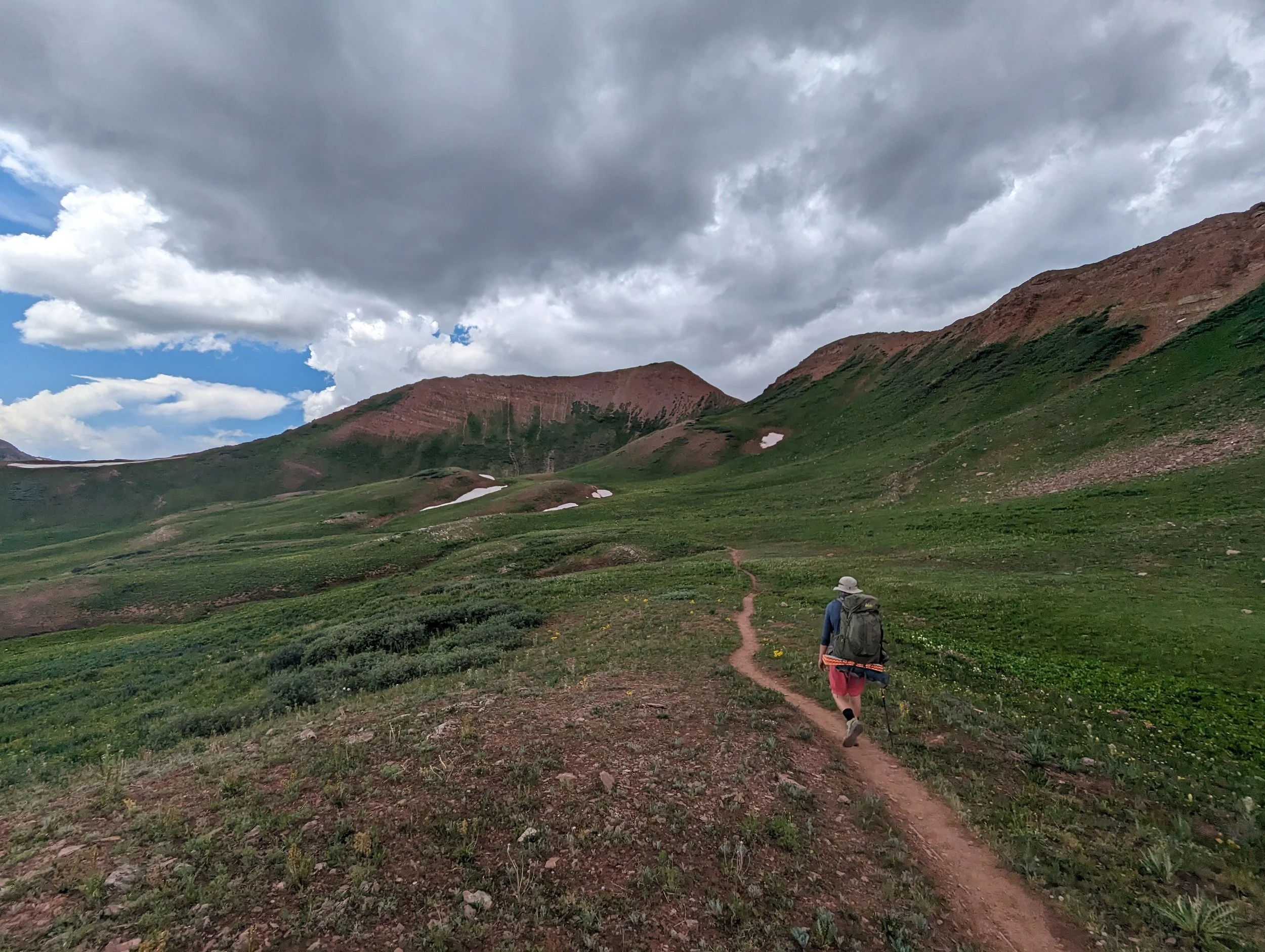
We joined the only other car at Avalanche Creek Trailhead shortly after 9, and after smearing on sunscreen and tossing the last few items in our bags, we hit the trail by 9:30. We hiked up the valley alongside Avalanche Creek, staying mostly in the cool albeit humid shade of the forest, with occasional water crossings to keep things interesting.


We plodded on for about 4 miles, the trail almost always slightly uphill, and despite the decent start time and the plentiful shade, we were dripping in sweat. Although we were making good time, our energy waned. We approached a clearing, recalling a trail description that marked a giant meadow as a midway point. As we neared the edge of the trees, we heard sticks snap to our right, behind us and off trail. We froze and turned, spying the small rounded ears of a juvenile black bear peeking over a log. It caught our eye and scampered off in the opposite direction. Energized by our brief animal encounter, we forged on.
Although we had reached a halfway point at this vast open meadow, we had gained hardly a quarter of our vert. Those legs were about to burn. Reaching the end of the valley, we met up with a trail junction before taking some continuous switchbacks up, up, and up. The last pitch of switchbacks was especially thigh-breaking, ending with a slow straightaway slog up just enough incline to murder your calves as well. Legs shot, we had now covered a good chunk of our vert but still had about a mile until we hit the lake. Carter was struggling. I pressed on, but the worst was yet to come. Thankfully, the view wasn’t so bad.
The blessing and the curse about the particular trail we were using, was that it was seldom used in general. In fact, in the two days we spent on the trail, we could count the number of people we saw on two hands. This lack of use, compared to more popular trails throughout Colorado, meant that a large portion of the trail was fairly overgrown. Plants were constantly thrashing our legs, which was a minor annoyance while hiking (thankfully, no poison ivy or oak), but did end up giving me some decent irritation once we landed in camp.
But the biggest consequence of this overgrowth were downed trees. Especially in the final mile leading up to the lake, Carter and I had to maneuver over, under, and around what could’ve been 20 (might as well have been 200) downed trees. Especially after taking our legs for all they were worth on the last big grueling ascent, any sort of diversion from the trail was met with moans and groans, heaving and squeezing our bodies (plus 30-pound bags) through nature’s obstacle course. I was too exhausted to get any pictures through this section. A few times, Carter almost gave up and camped under the tree he was in the process of crawling under.
Finally, I saw flat water, and immediately dropped my pack.
Legs cramping painfully, I walked slowly in circles, wolfing down a protein bar as I eyed an equally tasty snack hovering in the outlet stream to my right—a couple of meaty-looking trout. Too bad Carter left his pole in the truck. Eventually, my legs felt like working again, and I doubled back to encourage Carter for the last hundred yards. Finally, we both had reached the lake. It was a slog of a day.
We walked along the shore and quickly found an ideal camp spot in the trees, and found the lake to ourselves. Carter took a well-earned drink from the icy waters, before I stripped and took a waist-deep dip. Our bodies weren’t accustomed to the typical trail damage, and I could feel a few new blisters on my toes. Carter used the last of his energy to set up his tent, before sitting down, his back to a log, and staying there for as long as possible. We were beat. But man, did we earn that view.


While Carter dozed, I took a brief walk, finding some lovely Columbines on the far side of the outlet stream that held even more fish. Looking back across the lake, the mirror-like water, combined with the ever-shifting clouds, provided me with some excellent photographic opportunities (“photo opps” as the kids call them these days).
Between snapping pics and gaping in awe, I felt nothing but gratitude for the place I was in. Such majesty and grandeur that you can just… walk to.
That night, we feasted in our tent, testing out a variety of dehydrated backpacking meals. Unfortunately, Carter forgot to bring a spoon. Fortunately, he did bring a whittling knife. Note his rustic spoon sticking out of the bag on the right.
After dinner, we put all (or at least, most) of our food into a stuff sack and tied it up in a tree away from camp, typical protocol for food storage in bear country. On the Four Pass Loop, however, we would have to carry a bear-proof food container. Anyhow, we slept soundly that night, without any bear visitations (to our knowledge).
At dawn, I woke with the sun, brewed a cup of coffee, and watched the morning light show on the peaks.


By 9:30, exactly 24 hours from when we started our journey, we were on our way back.
The return journey was coming much easier to us. Granted, downhill is (generally speaking) easier on the muscles and harder on the joints, but overall we were feeling pretty good and recovered. Carter and I agreed that, although we were both pretty wiped yesterday, if we needed to hit the same stats a second day in a row, we would probably be able to muster up the effort. Still, we were grateful to be getting back to civilization (and pizza) that day. The miles passed, eased along by our easy conversation, a stark contrast to the not-so-silent struggle of Day 1.
We waded through shoulder-high fern forests, and trekked across familiar, serene meadows. Retracing our steps back across the creek, and finally through the endless forest. Almost 10 miles from leaving the lake, we made it back to the car.


To view more photos from our trip to Avalanche Lake, click HERE.
Back in civilization, we stopped by the grocery store for root beer and vanilla ice cream, then Taster’s in Snowmass Village for a giant, meaty pizza. Upon regaining cell service, I received some intriguing texts from my sister, Erin. She had been planning a camping trip to Telluride with some friends, and it initially seemed like our paths would cross there. But plans were changing. I gave her a call.
Erin’s friends had bailed on her at the last minute. But her car was packed and she, too, seemed to have a decent amount of free time. I mentioned our plans for the Four Pass Loop, but was open in my honesty about how difficult the trail may be, especially if she hadn’t done much hiking with a heavy pack recently. Still, she was more than welcome to join us. At the very least, with her car packed, she might as well make it out to Aspen and do some day hikes with us. I mean, why not?
It was dark when Erin’s car pulled into the gravel driveway. Although I was bummed for her sake that her friends bailed on her, I was nonetheless stoked that she was now joining us on our adventures. For our next mission, I proposed a solid day hike I’d done before, Electric Pass, near Cathedral Peak. At around 10 miles round trip, and being the highest trail-accessed pass in Colorado, it would be another good trek to test our mettle. I suggested if Erin wanted to join us on the Four Pass Loop, she should carry a full overnight pack to see how well she would manage. The next day, she went through the familiar rigmarole of discombobulating and recombobulating, while Carter and I took inventory.
Another run to REI, a stop at Walmart, then quesabirria tacos for dinner on the way home. We packed our bags, and the next day, we were ready again to hit the trail.


ELECTRIC PASS + CATHEDRAL LAKE
DIST: 10.5 mi / 16.9 km || ELEV: 3,800 ft / 1,158 m || CLASS 2 / MODERATE
After a beautiful drive up the Castle Creek Valley, through the tiny historic ghost town of Ashcroft, we turned off onto a short dirt road that led us to the trailhead, inhabited by only two or three other cars. Being a Friday morning, we were surprised, but certainly didn’t complain. The trail we would be hiking also led to Cathedral Lake, which is the destination for most people coming to this trailhead. We anticipated a fairly quiet day on the trail.
We hoisted our bags onto our shoulders—myself and Erin both carrying overnight packs, Carter carrying a daypack—and set off down the trail. I’d previously done this hike in the fall colors with my buddy Grant, and hiking through aspen glens for the first mile reminded me why I loved the trail so much.


By the time we left the trembling trees behind, the views only continued to improve. Unfortunately, the same couldn’t be said for my trailmates. In the cool morning, Carter had left the trailhead wearing a light fleece, forgetting he wasn’t wearing anything underneath. Soon, he was overheating, and opted to ditch the jacket, going shirtless for most of the hike. Erin, unaccustomed to her heavy pack and her boots, complained of discomfort almost immediately. Knowing that Erin often has more grit than she gives herself credit for, I did my best to rouse her spirit. I advised her to give it a mile or two to find her pacing, whether in footsteps or in breathing, and eventually she would fall into a good rhythm.


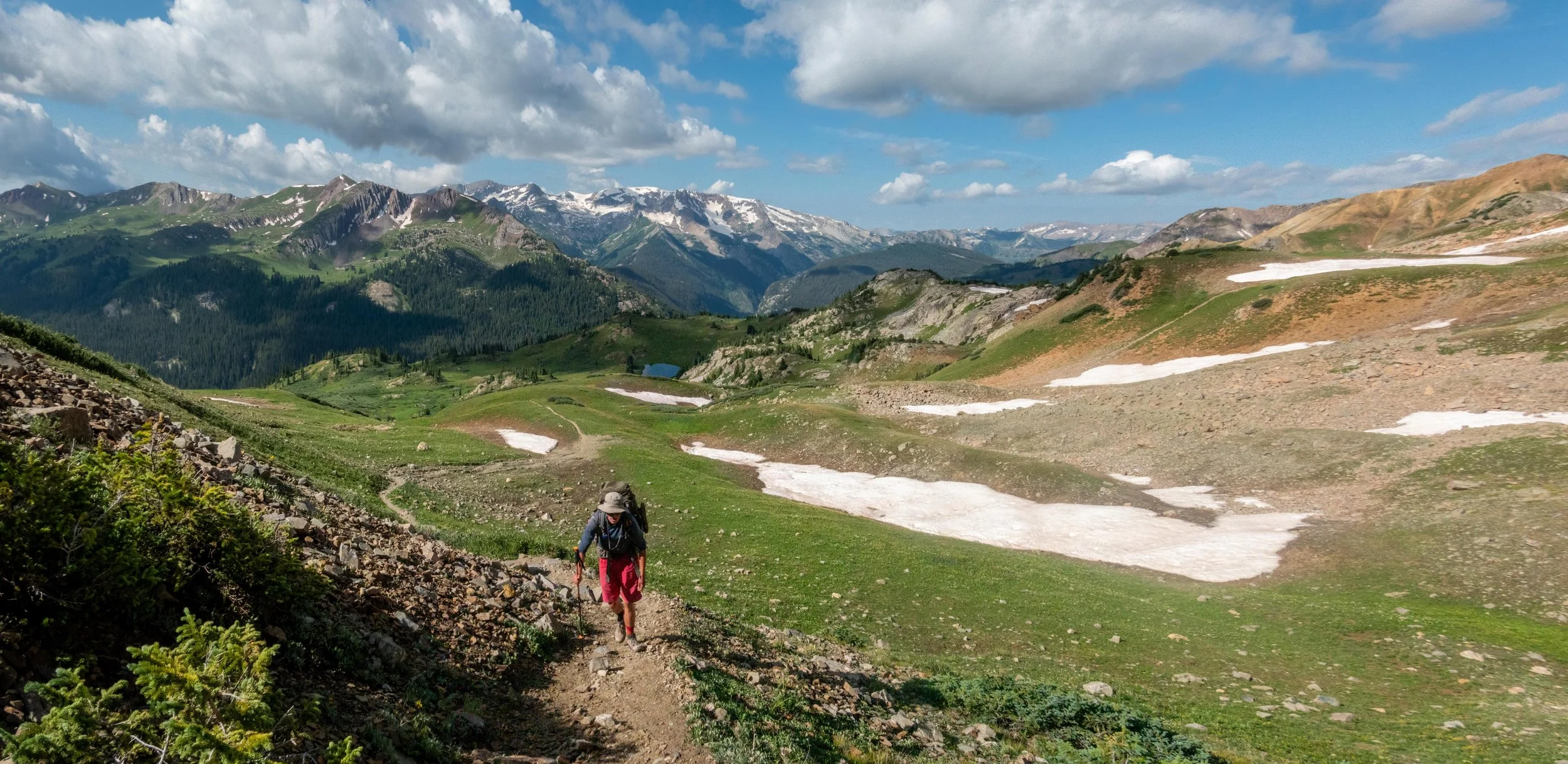
The trail climbed steadily up the valley, occasionally offering views of small cascading waterfalls. Erin’s discomfort had subsided, and by the time we reached our first major climb, we had all found our momentum. We marched up a set of steep switchbacks next to some beautiful cliffs, an exhausting section for many. Erin was doing great with her heavy pack, showing no sign of slowing. Quickly, we reached the top of the climb, and found the trail junction between Cathedral Lake and Electric Pass. First, we would head right to summit the pass, then double back to check out the lake, if we still had the energy.

Soon after the split in the trail, we broke above treeline and were treated with increasing amounts of wildflowers and epic views of Cathedral Peak. We hiked higher, slowly but surely entering the alpine tundra. As we climbed, Cathedral Lake slowly came into view behind us. Clouds constantly shifting overhead, I couldn’t stop snapping pictures of the epic peaks and ridges as they transfigured all around us in the ever-changing light.
We marched up into the alpine. Hardly any snow remained on the surrounding mountains; the trail was completely clear. The melt had nurtured the numerous wildflowers that surrounded us, from vibrant yellow to hot pink to light lavender to pastel green. We held a steady, although not hasty pace, eyeing the clouds gathering in the sky. We stopped for a snack break and discussed our options.
Clouds moved quickly overhead, although none of them were threateningly gray. It was nearing noon, a less-than-ideal time to be above treeline in a building thunderstorm. Still, the skies looked friendly and we hadn’t heard any thunder. Erin seemed to be handling her pack well. Carter and I still felt good. So after fueling up, we shouldered our packs, and continued the climb uphill.
The beauty all around us, from the flowers to the peaks, was simply breathtaking.


Soon, after a few long, sweeping switchbacks through small willow bushes, we could see the saddle above. To speed our pace, Erin and I decided to ditch our packs under a willow bush, pocketing some water and snacks for the summit. We sped off, walking with a lightness we hadn’t felt all day. We reached the saddle just after noon. The sweeping view back into the valley we had just climbed gave an immense sense of accomplishment. But we hadn’t made it yet.
From there, things got interesting. It wasn’t until I laid eyes on the home stretch of the hike to Electric Pass, that I recalled how sketchy it had felt the last time I was here. The final section involves a contouring traverse, following a faint trail across a vast sea of loose scree that drops sharply almost 1000 feet straight down to the bottom of the valley. Every step, rocks shifted underfoot. We moved carefully, deliberately choosing each foot placement.
We chose our route carefully, treading where others had clearly gone before. The path was faint, but we took our time with routefinding. The sketchiest part of the traverse was a patch of bare dirt covered in loose ball-bearing pebbles above the steepest section of hillside exposure. Two swift, confident steps, and we were past the small crux. Just beyond, we finally reached Electric Pass proper.
Meeting the ridge, our eyes found phenomenal views of Hunter Peak, Pyramid Peak, Maroon Peak, and Snowmass Mountain in the distance. In a few days time, we would find ourselves navigating over and around these mountains on the Four Pass Loop. Skies still looking fairly friendly, we sat and enjoyed our well-earned view, and our summit snacks.
CLICK HERE to join us on top of Electric Pass.
Not wanting to further tempt a lightning storm at a spot called Electric Pass, we eventually began our return journey. But first, we would go up. We quickly summited the adjacent 13,600 ft peak, a minute detour that prevented us from repeating our sketchy scree crossing. We met a hiker on his way down to the pass from the peak. Carter, still carrying his fishing gear on this high mountain ridge, despite the obvious lake lying miles behind us, wanted to make a crack to the hiker about looking for the lake. But the hiker beat him to the punch. “Not a lot of great fishing up here, I’m afraid,” he chuckled as we passed, causing us to giggle. Carter figured since he was up here anyways, he might as well look.
From the top of the peak, we started our descent back towards the lower saddle. Every few feet, the color of the rock below us would change, from a deep red, to a burnt orange, to smoky maroon, to moody gray and green. The quality of the rock was much more solid here; a few spots we scrambled over or around small formations along the ridge, admiring the beauty all around us. Darker clouds began to form as we made our descent, but thus far, we hadn’t heard any thunder, or seen any lightning.


Back in the valley, we scooped up our packs and continued our descent while praying the rain away. Thankfully, we stayed dry all the way back to treeline, where we returned to the fork in the trail. After a brief discussion, we felt like we still had gas in the tank, and we decided to check out Cathedral Lake. A quick quarter-mile and a creek crossing later, and we arrived at the serene shores beneath Cathedral Peak.


Erin dropped her pack, quickly donned a swim suit, and dove right in, instantly refreshed. Carter busted out his fishing rod, and though we could see numerous trout from shore, he didn’t seem to be having any luck. He ditched the pole and grabbed his net, wading out into the shallows, attempting to sneak up on the slowest fish he could find. I chuckled and walked down the shore, studying the technicolored wildflowers that lined the path. Soon I would learn their names— Larkspur, Pink Elephant, Fireweed, Rosy Paintbrush…


Finally, after spending about an hour at the lake, with still hardly a drop of moisture from above, we repacked our bags and hit the trail back to the car. It had been a lovely albeit hefty day. We were all feeling really good.
I was especially impressed with how well Erin had been handling the mileage and heavy pack at elevation all day. Especially considering she hadn’t been hiking at all recently, and she hadn’t had proper acclimatization time, I thought she did far better than expected, keeping pace with Carter and I fairly well for the duration of the hike. I was confident she’d be able to tackle the Four Pass Loop with us. I fished for her feelings, but she said she’d still have to think on it. After all, this had been a single day of backpacking; Four Pass Loop would be three consecutive days, sleeping in tents in the backcountry, rather than beds in a nice house. I understood her concerns, but reassured her she was up for it.
To view more photos from our trip to Electric Pass and Cathedral Lake, click HERE.

The next day at the house was all business: full-on preparation for Four Pass Loop. Carter had booked the camping reservations, now we had to figure out “the rest”. Erin decided against doing the full loop with us, but was happy to see us off down the trail. So, considering our overnight parking options, plus the addition of Erin’s car, we came up with a plan.
We’d first leave Carter’s vehicle at Buttermilk Mountain, where overnight parking was cheapest and most reliable, before hopping into Erin’s car and heading to Aspen Highlands, the pickup spot for the shuttle up to the Maroon Bells. The three of us would catch the bus at 8:45 to get to the Maroon Bells Trailhead. From there, we would all hike to Crater Lake, where Erin would leave us and head onto her next destination while we completed the loop. The catch was that by leaving Carter’s vehicle at Buttermilk (mostly to save a buck), we’d have to take 3 different buses, including the shuttle, in order to get back to his car at the end of our long hike. Still, we felt it was worth it.


Fees paid, reservations made, and transportation organized, we turned our attention to food and gear. We prepped some homemade cereal—dry milk, granola, oats, nuts, chocolate, and dried fruit were added in various portions. We used the last of our sliced meat and cheese to make some quick and easy lunch wraps. We had stocked up on dehydrated dinners over our various trips to REI, so the only thing left to pack were some snacks.
To view my full packlist for the Four Pass Loop, click HERE.


As we spread everything out, we felt immense gratitude to the Long family for allowing us to use their beautiful home as a basecamp. It provided plenty of room for food prep and gear staging! We truly cluttered it up to the point of madness, and did our best to leave it clean and tidy.
FOUR PASS LOOP
DIST: 27.1 mi / 43.6 km || ELEV: 7,750 ft / 2,362 m || CLASS 1 / STRENUOUS

Carter, Erin, and I arrived at Aspen Highlands early. It paid off; despite our 8:45 bus ticket, there was still room on the 8:30 ride. Granted, standing room only, but since we were on the front end of our mountain marathon, our legs were ok with standing for the 10-minute drive. I had never seen the Maroon Bells in person before, largely due to my tendency to avoid touristy (especially fee-heavy) spots, so I was excited just to get to the trailhead.
Once we were off the bus, we walked the short distance to Maroon Lake, where the iconic view of the Maroon Bells presented itself. Although I was absolutely thrilled to be doing the full hike, I could understand why this beautiful spot, with its well-graded paths and clearly defined boundaries, was as far as many people made it. Aspen trees lined the valley; this view would be lit up gold in just a few months. We paused for a moment to admire the beauty and snap a few quick pictures.

We weren’t long for the land of well-graded paths and clearly defined boundaries, however. We followed the easy trail around the lake and began to hike up the valley. Shortly, we came upon a classic wilderness boundary marker, accompanied by a metal container of free, but required, self-issue hiking permits. As we filled out the necessary information, a few forest rangers approached us from the trailhead. They were in their mid-twenties and were extremely friendly. They had a quiz for us.
“Morning, guys! Mind if we ask you some questions?” We were happy to oblige.
“Where you guys camping?” Carter, having made the reservations, answered quickly, “East Fork and North Fork zones.”
“What’s your food storage solution?” As required for backpackers in the Maroon Bells-Snowmass Wilderness, we carried a bear-proof container. Thankfully, they didn’t make us pull it out of Carter’s stuffed pack to show them.
“What’s your waste disposal solution?” Erin had provided us with some wag bags, essentially heavy-duty, smell-proof ziploc bags to carry out human waste. I mentioned these, but the rangers reassured us that burying our poop at least 6 inches deep, 200 feet away from water sources, would also be acceptable.


A quick digression: poop disposal is a growing discussion in many outdoor circles, especially as popularity of outdoor activities has exploded in recent years.
Leave No Trace mentions the “pack it in, pack it out” ethos, but suggests a “cathole” similar to what the ranger had told us. As more people head outside and into the backcountry, the cumulative effect of everyone digging and pooping in catholes would be an environmental nightmare. So the obvious, albeit somewhat gross and tedious solution is to carry your poop out. On this trip, we would take a page from each book. If we found ourselves above treeline when nature called, we would pack our poop out; if we were more in the trees, we felt that a good hole would suffice.
The rangers seemed pleased with our responses to their pop quiz. Thankfully, we had studied.
“Do you mind if we take a look at your camping reservations?” My heart sank. I knew had I received them in an email, but we were now far from service, and I had foolishly forgotten to download them. I opened my phone and quickly scrambled through downloaded files, screenshots, anywhere I might’ve saved proof of our permission to camp. The rangers were graceful. “You guys came prepared and answered right away when we asked about camping zones, so we trust you’re good.” Just then, the reservations popped up in my email. I showed them to the rangers, they verified what we had told them, and they sent us on our way, wishing us luck.
All too quickly, we arrived at Crater Lake. “We’re here already?” Erin lamented, knowing this was as far as she’d planned to come. After a double-digit day on Electric Pass, the mile and a half to Crater Lake flew by too easily. I knew she was off to other adventures, but I prodded that she definitely would’ve been physically able to join us on the full loop.
Carter plopped down to don his hiking boots and munch on a snack, while Erin changed into a swim suit and waded out into the mirrored waters for a refreshing dip. I walked along the shore, climbing over tangles of fallen logs, looking for the best angle of the lake and Maroon Peak.


Day 1 of 3 would have us conquering our first pass, West Maroon Pass. Carter and I wanted to be at the top by noon, so we had to be on our way. After about half an hour hanging out by the lake, we said farewell to Erin and started the march upward along West Maroon Creek. The valley was overflowing with wildflowers; thankfully the river was not. We were able to step across without getting our feet wet. As we neared treeline, the sun burned hot overhead. But our eyes were on the beauty all around.


Climbing into the alpine tundra, we left the river behind, but still found plenty of wildflowers—Indian Paintbrush, Silvery Lupine, Marsh Marigold, Moss Campion…


Approaching the final steady climb to West Maroon Pass, we found our last opportunity to fill up our water bottles just below a melting snow patch. Unsure how available water would be on the far side of the pass, we filled all our bottles to the brim.


The climb to the top of West Maroon Pass was steady, although not particularly difficult for us. We passed two backpackers who had been taking frequent stops. Unwavering, we marched up the vibrant orange trail towards spotty blue skies. Behind us, dark clouds brewed in the valley.
Before we knew it, we had reached the top of the pass, with much more promising skies on the far side. We sat and enjoyed the view and a quick lunch


Pass 1 of 4 conquered, we set down the far side as a small crowd started forming on the summit. Our descent into the East Fork Zone was so scenic, with the Raggeds Wilderness ahead in the distance, the lush valley stretching before us, and the shifting clouds playing light across the entire scene. We would be camping in this zone tonight before climbing pass number two tomorrow, but we didn’t see any obvious campsites as we hiked. We knew we wanted to find a spot with easy access to a water source, but lingering snowfields were much less abundant on this side of the mountain. We kept our eyes peeled, enjoying the scenery along the way.


Eventually, we stopped losing altitude from the pass, and began to traverse above the valley floor. The sky above us began to darken and grumble ominously. Judging by our map, we were getting close to the end of our camping zone. We had pinpointed a small lake below our next pass that we hoped to camp at. We still hadn’t seen any obvious campsites thus far. As we continued, the trail started climbing slowly. Soon, we were able to spot Frigid Air Pass up to our right; the trail looked a bit steeper and rockier than West Maroon Pass. After walking through a fairly marshy section below some diminutive snowfields, we climbed a small hill and finally laid eyes on the lake below the pass.
Maybe “lake” is a bit generous here—it was little more than a small pond of brown opaque water. I set my pack aside and walked around for a bit, scouting for a suitable campsite. The sky growled, a bit louder this time. I quickened my pace. We had been hoping to find a campsite with running water, but thankfully we had topped up before West Maroon Pass, since there was none to be found here. Eventually, Carter and I decided on a slight hilltop that looked as if it had been camped on before.

Having found our spot for the night, Carter and I dropped our packs, and the sky dropped the rain. With a loud crash, the clouds opened and started dumping on us. We scrambled to get our tents unstrapped from our bags. I unfurled the carefully packed roll, and almost instantly lost my rain fly in a sudden gust of wind. I snatched it from the ground and stuffed half of it in my pocket while I wrestled with the tangle of poles and mesh.
The rain beat down unrelentingly with what felt like vengeance. Wind whipped the lightweight tent fabric in my hands as I struggled to shove circular objects into circular holes. Cursing, I began to piece together the bottom half of my tent, but still had to attach the rain fly and stake it all down to keep it dry and in place. We worked as fast as we could, but prioritizing setting up shelter over keeping our bodies dry, we were quickly getting cold and wet.
Over my shoulder, I heard a curse. One of the 15-year-old poles of Carter’s tent had broken at its connection point.
The rain didn’t care. Carter wrestled his tent pole into submission for the time being, while I finished hammering in the last few stakes with a rock. Starting to shiver, I shoved my pack under the vestibule and dove into shelter. I quickly took off my now damp jacket, and used it to wipe up a significant amount of water from the floor of the tent. At this point, my fingers were numb. Having been wearing only athletic shorts, I donned long underwear and pulled out my blanket, set on bringing my body heat up.
Carter, meanwhile, finally got his tent into place and loosely threw his rain fly over the top. We sat in our tents and waited out the rain for another few minutes.


When the downpour finally abated, we stepped outside and took our chance to look around. Behind our tents, we could see the climb to Frigid Air Pass, the start of Day 2 laid out plainly before us. In front of us, the views were panoramic. Far above treeline, we had uninhibited views for miles in every direction. The sky slowly but surely lightened. Surrounding our small dirt patch were a colorful assortment of wildflowers. Thanks to the rain, the valley glowed vibrantly green. This was not a bad spot.

After a brief walk around, we were ready to dive back into shelter to warm up. Between cloudy skies, the rain, and a slight breeze, a chill had set in quickly. We relaxed for a bit in my tent and discussed dinner. I wasn’t as hungry as I was tired, so I said I’d like to lie down for a bit before eating. Carter agreed and went back to his tent, each of us crawling under our respective covers to warm our bones and relax. The sky slowly darkened, and without realizing how exhausted we really were, we both dozed off.
It was completely dark when I woke up. Carter was talking to me from his tent.
“Kyle. I’m hungry. Wanna make dinner now?” Groggily, I pawed around for my phone and checked the time.
“Dude, it’s 2 in the morning.” We had hardly even realized we were asleep, and we had slept for almost 6 hours already. “Oh.”
“I’m going back to sleep.” I rolled back over and turned my phone off.


I woke when light first hit my tent, poking my head out to gaze at the beautiful morning. I quickly brewed a cup of coffee and sat cross-legged in the open door of my tent, simply watching the day begin. By the time I had drained my cup, Carter was awake, so I brewed a second. Together we sat and soaked in the first rays of sun since midday yesterday. Carter whipped up a dehydrated meal of biscuits and gravy while I stirred water into a bag of dry cereal. We shared both meals, packed up camp, and hit the trail.
The hiking started immediately, but thankfully our legs were feeling fresh. After passing the small pond, we started the steady climb to Frigid Air Pass. Having camped only 400 vertical feet below the pass, the climb wasn’t nearly as long as the climb to West Maroon, although it was definitely steeper. In one section, a patch of bare dirt felt almost reminiscent of the sketchy part on Electric Pass, but since we were climbing rather than traversing, we were able to move past it without any difficulty. We approached the summit less than 30 minutes from leaving camp.
Topping out on Frigid Air Pass, we were treated with an epic view of Maroon Peak.

Pass 2 of 4 complete, but only beginning our day, we didn’t loiter for long. Today would be an interesting one: we began with a quick and easy half-mile climb, next we would descend over 4 miles and 2000 vert, before climbing right back up 1500 feet of that lost vert in only 2 miles, finally finding a suitable campsite below Trail Rider Pass. Thankfully, the descent into the spacious Fravert Basin was scenic enough to salve the wound of lost vert.

At our first opportunity, we stopped to fill up water bottles in a crystal-clear snowmelt stream. Ultimately, skipping dinner had worked out to our advantage, as it significantly cut back on our water needs. But after two cups of coffee and breakfast for each of us, Carter and I were both down to a few swallows. After topping up, we continued our descent.


Now in the lower valley, the trail followed the North Fork of the Crystal River. We kept our eyes peeled for moose, thinking this seemed like their ideal habitat. But no luck.
Eventually, we made it to a proper creek crossing. We were making good pace, and not particularly feeling in the mood for the rigmarole of taking my boots off before putting them right back on, I paced the bank, looking for some good stepping stones. Upstream, no luck. Downstream, no luck. Carter joined me on the bank, eyeing the situation. Just then, a few backpackers wearing light trail runners, arrived at the opposite bank.
With almost no hesitation, they marched right through the water, only about ankle deep, and stepped onto our bank. “That’s one method,” I chuckled. “They’ll dry out soon enough,” they replied with a cheeky grin before they headed on their way. I decided I might have to give it a go. Thinking (foolishly) if I were to get a little more speed, I’d move through the water quickly enough, and the waterproofing in my boots would keep my feet dry. Deciding against delacing, I leapt out into the river.

With one- two- three- four- explosively splashy steps, I reached the far bank, half soaked in the process. “Well, that was dumb,” I laughed, shaking my head at myself, disappointed but not surprised. My boots, and the feet inside, were soaked. Carter, seeing how poorly my run had gone, decided he could probably do better.
One- two- three- four- giant splashes later, and he promptly found himself on the far side, somehow even wetter than I was. “Worth a shot, right?” We plodded on, dripping.
Before long, we began to regain the vert we had been descending all day. The sun hung high, and we baked down in the valley. Humidity oozed from the abundant plant life all around, causing us to sweat through our already wet clothes. The trail gradually steepened and our legs started feeling the burn. One foot in front of the other, we trudged uphill. The trail switched back occasionally, but we could never really see the top of our climb. We just knew we needed to go up.


Wanting to get it over with, I charged ahead, setting an aggressive pace and pausing every few minutes to catch my breath. With each squishy step, I cursed myself for getting my boots so wet. Carter stuck with a slow and steady pace, struggling but making good progress up the climb. Behind us, Maroon Peak rose into view. Spurred on by the ever-improving views, we put the vert behind us.


Finally, we reached a good resting spot, having climbed 1200 feet of vert from the bottom of the valley. We found a nice spot to sit next to a stream and ate some lunch. A small family of marmots peeked out from the bushes, circling us looking for scraps. We tucked away our wrappers, filtered a bottle of water each, and set off for the last bit of the day.

Shortly, the trail flattened out as we reached the uppermost basin beneath Trail Rider Pass, our first objective for tomorrow. There was a lake, like a proper lake, and there seemed to be plenty of options for camping. It was early in the afternoon, and not another soul was in sight. We debated camping close to the lake we could see from our vantage, but went on a quick scouting mission first. We climbed to a small flat area on a hillside just above the trail. There, nestled in short willow bushes was the evidence of a previous campsite. Exploring the area briefly, we found a couple other empty sites above ours, but more tucked back into the trees. Returning to the original site, we took a proper look around. With sweeping views of the whole valley, as well as the Maroon Bells, we knew this would be the spot.

We dropped our bags and took a quick stroll to the outlet from the lake, bringing all of our water containers. We topped up for that night and the next morning, and walked back to camp to settle in. We leisurely set up our tents as clouds shifted overhead, lacking the threatening growl from the day before. I unpacked my bag and tucked it under the vestibule with care. Our campsite almost fully set up, I stepped back and looked around.


This was seriously one of the more beautiful spots I’d ever had the privilege of setting up a tent. “Dude,” I said, almost giddy, “This is all time!”
By 2pm, we had settled in, but with an epic campsite, and not much energy for exploring, we had no reason to leave.
I pulled my sitting pad up next to Carter, and together we just sat and watched the view, enjoying dry afternoon weather for a change.
In the 10 years I’d been in Colorado, rarely had there not been a burn ban for most of the summer. This usually rules out campfires, but this year, with the plentiful winter snow, and an already fairly damp summer, we realized we’d be able to revel in the smell of smoke. We gathered up a few small sticks, none bigger than our wrist, from a few dead trees we were probably camped too close to. Soon, these sticks were alight in our backcountry hearth.


Carter and I decided we should actually have dinner tonight, and decided on a three course meal. We would start with beef stroganoff, before taking a trip east of the border (which border?) with chicken teriyaki, and finishing with some meat lasagna. At our campsite at 11,400 feet, each meal would take almost 30 minutes to fully hydrate, so we decided to spread our courses out over about two hours.
It was a fine plan, and one we planned on executing with much enthusiasm. Carter poured a pot of water, while I brought the stove to life.

We fed ourselves. We fed the fire. We watched the light shifting through the clouds and saw rain pass us by.
It was a good evening with great company in an amazing place.
What more can you ask for?


As we sat around the fire that night, from outside its sphere of light, we heard rustling in the bushes. Carter clicked on his headlamp and pointed it in the direction of the sound. The light wasn’t super powerful, and we could only see two glowing eyes watching us from the darkness. Something ancient and primal stirred in my stomach; my heartrate spiked and I felt a pit of dread in my gut. I snatched up my headlamp, which was slightly more powerful, and swung it towards the eyes.
On the edge of our camp stood a deer in the darkness, eyeing us with suspicion. I breathed a sigh of relief, putting a hand to my chest. Carter and I laughed at ourselves as the deer returned to munching on grass.
Soon, the fire wound down and so did we.


Early, as usual, I was stirred awake by my bladder. My eyes slowly opened to see the canopy of my tent glowing. Peeking my head out of the tent door, I stifled a scream. I scrambled for my camera, quickly strapped on my sandals, and leapt out into the glorious early morning light.

I put on a cup of coffee, and soon, Carter started stirring in his tent. Today would be the day we finished the Four Pass Loop. But we still had 2 passes to tackle today, with over 10 miles until we got back to the trailhead. We’d then have to take the shuttle back to Highlands, catch a bus there to take us into town, and then a third bus to take us to our car. We had a long ways to go. I was antsy to get going, but it wasn’t until the sun was fully up that Carter finally emerged from his tent. We ate a quick cereal breakfast with our coffee, took one last look around at one of the best campsites we’d ever had, and began to pack up our tents.

By 9am, we were back on the trail. We walked back down past the small lake, and began to go uphill. The climb to Trail Rider Pass was steady, although not at steep as Frigid Air. The rugged ridges of Hagerman Peak rising to our left provided an excellent backdrop for photos. As we put one foot in front of the other, we were treated with increasingly fantastic views of the Raggeds Wilderness behind us as well.

Within 30 minutes of leaving camp, we topped out on Trail Rider Pass. As we crested the top, we could see to the bottom of the valley on the far side, where Snowmass Lake sat below towering peaks. Fairly quick and painlessly, Pass 3 of 4 was complete!
To our right, the long west ridge of South Maroon Peak extended above us, still covered in a few decent-size snowfields. As we started our descent on the far side, I enviously spotted some faint snaking ski turns down one of the snowfields. I knew I should’ve carried my skis and boots this whole way!
As we plodded downhill, we remarked we were grateful we had done the loop clockwise, as the climb from Snowmass Lake seemed like it would be a rough one. We had heard similar about the climb to Buckskin Pass from Crater Lake, so we were glad to be coming at it from the back side. 3 passes conquered, 1 to go, we forged on.
The trail descended quickly at first, before leveling off a bit and starting to traverse around the lake. The whole basin was absolutely beautiful; we could see why camping permits for the Snowmass Lake Zone were so hard to come by. But, with campfires prohibited at Snowmass Lake, and due to the fact we had only seen one other party of 3 people from our campsite, we were extremely happy with where we had stayed the night before.
Before we knew it, we were back in the trees, and started to contour around to the valley that would lead us up to Buckskin Pass. As we traversed above the lake, we crossed a few boulder fields. A couple of them had lingering snowfields, and we took our time, stepping carefully to avoid slipping down the suncupped surface. We were extremely grateful to have our trekking poles here.


Past the sketchy snow, we found a creek crossing before slowly but surely starting our ascent through meadows of wildflowers towards Buckskin Pass.


Before our final climb, Carter and I stopped to fuel up. It was a warm day and we were both dripping in sweat. I swallowed an energy goo while Carter forced down a pop-tart. We still had energy in our legs, but we were feeling the pain. Sufficiently fueled, we shouldered our packs and started the slog uphill.
We steadily climbed up towards the north ridge of Maroon Peak, and before long, we were back above treeline. Peaks towered around us as we urged our legs on.

Behind us, Snowmass Mountain slowly rose into view. Dark clouds gathered overhead, rumbling their warning at us. Above, we could see specks of people standing atop our final pass. The weather was ominous, but we didn’t want to lose momentum. It started sprinkling. We kept going. Well above treeline now, the views were spectacular, but we were at the mercy of the weather.


Thankfully, the sky relented after some light rain, and before we knew it, we were at the top of Pass 4 of 4!
We could see straight across the valley to Pyramid Peak, as well as Maroon Peak off to our right.

Clear skies hung above us as we sat down to enjoy the view, and a light lunch.
CLICK HERE to check out the top of Buckskin Pass yourself!


Our final pass conquered, it was all downhill from here. Again, we remarked that we were grateful to be going down the east side of Buckskin Pass on our last day, rather than slogging up it on our first. Wildflowers were plentiful on our descent down the fairly steep and steady trail. Soon, we were back to treeline, and we stopped to fill our water for what would be the last time. Pyramid Peak provided a great backdrop for our descent back to Crater Lake.


By the time we reached Crater Lake, we had about a mile and half to go back to the trailhead. We bypassed the lake, heading straight for the end. Our shoulders and hips ached from carrying heavy packs the past three days, our feet had their fair share of tape-wrapped blisters, and our stomachs grumbled for food that didn’t come from a bag.
The last mile felt longer than we remembered, but before we knew it, we were walking the shores of Maroon Lake, back in the land of graded paths and boundary markers.


We paused, taking one more long look at the Maroon Bells. I knew it wouldn’t be my last.
To view more photos from our trip around the Four Pass Loop, click HERE.
Three bus rides, a car ride, and a trip to the grocery store later, we were back at the house on the hill.
For dinner, bacon cheeseburgers. For breakfast, chocolate chip pancakes. We agreed it was the best food we had eaten in our lives.


Our mission in Aspen complete, we took a few rest days.
I plugged away on the computer, editing the hundreds, if not thousands of photos I had gotten in the past few days. Carter turned his attention to our next destination, reading up on mountains to climb and trails to check out. We had been hanging out in Aspen for almost two weeks, but it was time to move on…

