
FREE TIME - Part 2 | On the Road
Cars loaded up, Carter and I said farewell to the Longs’ house in Aspen and hit the road once again.
We headed east through town, and soon, the meandering road began to climb through vibrant aspen glens into the headwaters of the Roaring Fork River. This historic route over Independence Pass is a winding and narrow road, in places only wide enough for one car to squeeze between a rock wall and a vertical dropoff. It’s a beautiful road I’ve driven many times, even in a 25-foot box truck when the route via Glenwood Canyon was closed. The road is closed during the winter months, when drifting snow and avalanche hazard would make travel extremely dangerous. Any time I get to make the journey over the 12,000-foot pass is a treat.
It was mid-afternoon when we passed the tiny town of Twin Lakes on the far side of the pass. A little further, and we turned into the driveway of Aspen Whitewater Rafting, a small red building with yellow boats stacked outside. In a grassy field down by the river, we saw a familiar van. The awning was out and Bobby and Mary lounged in the afternoon shade. They rose with their two dogs to greet us.

Carter and Bobby had trained as raft guides together in Idaho Springs, where I worked as a whitewater photographer at the time. We worked together for only a brief time, but Bobby had gone on to do some really cool things: guiding in the Royal Gorge and on the Roaring Fork and Arkansas Rivers over the previous summers, and traveling all over to bike and surf in the off-season. His van was fully built out, laden with the toys and trappings of off-grid living.
About a month prior, Bobby had guided us down a section of whitewater near Aspen called Slaughterhouse Falls. It was one of the last days of the season for that particular stretch of river, but we were able to rally an after-hours trip. Despite the low water, we had had an amazing time with him and his friends from AWR.
Here’s a small taste of the day:
Over the past few days, we had texted back and forth about doing another trip, and decided we would run a section of the Arkansas River called Numbers. It was a popular Class IV section of river that I never had the chance to run, so I was stoked! We strapped a 10-foot raft to the roof of Mary’s car, hopped in Carter’s truck for a shuttle, and set off for the put-in, a quick 15-minute drive from the outpost. On the way, we stopped and scouted a section of Class V whitewater called Pine Creek.

At Numbers Recreation Site, Mary and I lounged in the raft and chatted, while Carter and Bobby set shuttle. Before long, they returned and all together, we maneuvered the boat down to the water. I clipped on my helmet and cinched my PFD, soaking in the sound of the burbling river. We snapped a quick pic on shore, and then pushed off into the current.
It felt great to be sitting in a raft and paddling again. The weather was perfect. The views were stunning. Floating downstream with good company and good tunes, we absorbed the world around us.
Having done plenty of commercial guiding on Numbers, Bobby took us down without trouble. The trip was solidly splashy, and although the water was low and warm, I was grateful to be wearing splash pants. As with any rafting trip, the end came far too soon. Grateful to see a new stretch of river, I profusely thanked Bobby for making the trip happen.
Back at the outpost, we hung cam straps between our cars to dry our clothes. That night, Carter and I cooked brats on the back of his truck, watching the stars appear slowly overhead. Peacefully parked riverside, with the twinkling night sky above, we crawled into our vehicular homes, bellies full and appetites for adventure satiated.
Early the next morning, we rose before the sun. You see, we had a plan.
The idea was to climb La Plata Peak, a nearby 14er (a peak over 14,000 feet), so I loaded my daypack into Carter’s car and we set off for the trailhead. 14ers are plenty and popular in Colorado, and when we reached the parking lot around 5am, it was already filling up with cars. I hadn’t really done much research on the route, but from a description Carter read to me from Gerry Roach’s book, it didn’t sound technically difficult. Knowing the popularity of 14ers, I figured the trail would be hard to miss, so (foolishly) I decided against bringing a map. We knew the first section of the trail would be along a dirt road, so we parked our car and began to walk down the road.
Although stars still glimmered overhead, morning was creeping up on us. Wanting to make good pace, I marched ahead on the dirt road, recalling (incorrectly) that we would be on this road for a little over a mile before the trail split off. To our left, what we thought was La Plata Peak rose into view. Any moment, we expected a trail branching off to the left, but it never came. After about 45 minutes of walking down the road, we began to seriously question our sanity.
I knew I should’ve brought the map. Neither I nor Carter had downloaded a GPS map onto our phones, either. We were moving in the dark. We felt stupid.
We stopped and discussed. Carter clarified that the trail turn-off would come in the first quarter-mile, not mile-and-a-quarter. My head swam, feeling foolish for charging blindly ahead, so certain that I would be able to discern the trail along the way. We had wasted almost an hour, and we would have to backtrack almost 2 miles to get back to the actual trail. We would essentially be starting from square one, 2 hours and 4 miles into our day.
The sun started hitting the high peaks around us, bathing them in a beautiful morning glow.
We had wasted too much time. We didn’t feel like adding 4 miles to what would already be a 10-mile day. Despondently, we decided to abandon our summit plans for La Plata Peak. We hiked a bit further up the road, enjoying the glorious sunrise and the warmth that came with it. We didn’t go far before we decided to pivot our adventure.
Although we hadn’t made it to our intended destination, we were still in a beautiful place. We took a moment to look around, grateful in spite of our grief.
We decided we would head back to the car, and continue exploring up the valley on four wheels.
Back at the trailhead much sooner than we expected, we hopped in the truck and turned back up the dirt road. Ever since I got my first offroad-capable vehicle, a 2001 Toyota 4Runner, cruising mountain roads has been one of my favorite things to do. From easy dirt driving on forest service roads, to rocky technical offroading on old mining trails, I’ve been able to find adventure and beauty around every turn.
We rambled easily up the road, past the spot we had walked to that morning, and continued up the valley. Soon, we came to a split, and decided to take the road to the curiously-named “Peek-a-Boo Gulch.” The temperature was perfect, without a cloud in the sky. We reached an opening in the willows, and came upon the most vibrant river I’ve seen in the Colorado high country. Due to the excellent snowpack and moist summer, it weaved its way powerfully through the unusually verdant valley.
We continued up the picturesque basin, rambling over rocks and bouncing in our seats. At the top of the valley, we found the source of the red river, an appropriately-named Red Mountain. Remains of an old mine littered the valley, and the road ended at a small portal, blocked off with a metal barricade. We were at a beautiful spot on a beautiful day. Even though it hadn’t all gone according to plan, we felt like we made the most of our day.
It was nearing noon and we wanted to be moving on. We retuned back down Peek-a-Boo Gulch to La Plata Trailhead, swinging by AWR to hop in my car and say farewell to Bobby and Mary. Our next stop would be the Uncompahgre Wilderness, where we would attempt a couple of 14ers, hopefully with more success than La Plata. After a quick grocery stop in Gunnison, we headed south to Lake City, a small town of less than 500 people. It’s a popular pitstop for travelers on the Alpine Loop, a rugged backcountry road connecting it with the towns of Silverton and Ouray. The streets crawled with side-by-sides and kitted-out jeeps. I puttered along proudly in my minivan.
Our next move would be to find a camping spot for the night. We headed west out of town along the Alpine Loop. Soon, we came upon the remarkable site of the Ute-Ulay Mine. According to a placard at the site, the mine had begun operating in the late 1800s, producing more than $300 million in today’s dollars. The mine essentially built the town of Lake City, bringing in the people to dig the ore up, and the railroad to ship it away.
Curiously, the mine was named after the Ute Chief Ouray, the same namesake for the town of Ouray. Except here at the mine, it was spelled Ulay or Ule to reflect the Ute pronunciation of their chief’s name. Pronunciation of “Ouray” is a topic of debate amongst Coloradoans, so does this settle the score?
How do you pronounce Ouray? Oo-ray? Yer-ay? U-lay?
We continued up the road as the sun sank behind the mountains. It wasn’t difficult driving, but for my minivan, it was a bit bumpy, so we took it slow.
Just before dark, we found a suitable pulloff and set up camp for the night. We had big plans for the morning.


UNCOMPAHGRE PEAK
DIST: 13.1 mi / 21 km || ELEV: 4,700 ft / 1,430 m || CLASS 2 / STRENUOUS
We started moving early. Since access to the trailhead necessitated high-clearance 4-wheel-drive, we found a good spot to stash my van and head up in Carter’s truck. We would be starting from the Matterhorn Trailhead, which is not the typical trailhead for Uncompahgre Peak, but we were hoping to tackle Wetterhorn Peak on the way. The trail to and from Uncompahgre alone would be a half-marathon, so we decided we’d feel it out.
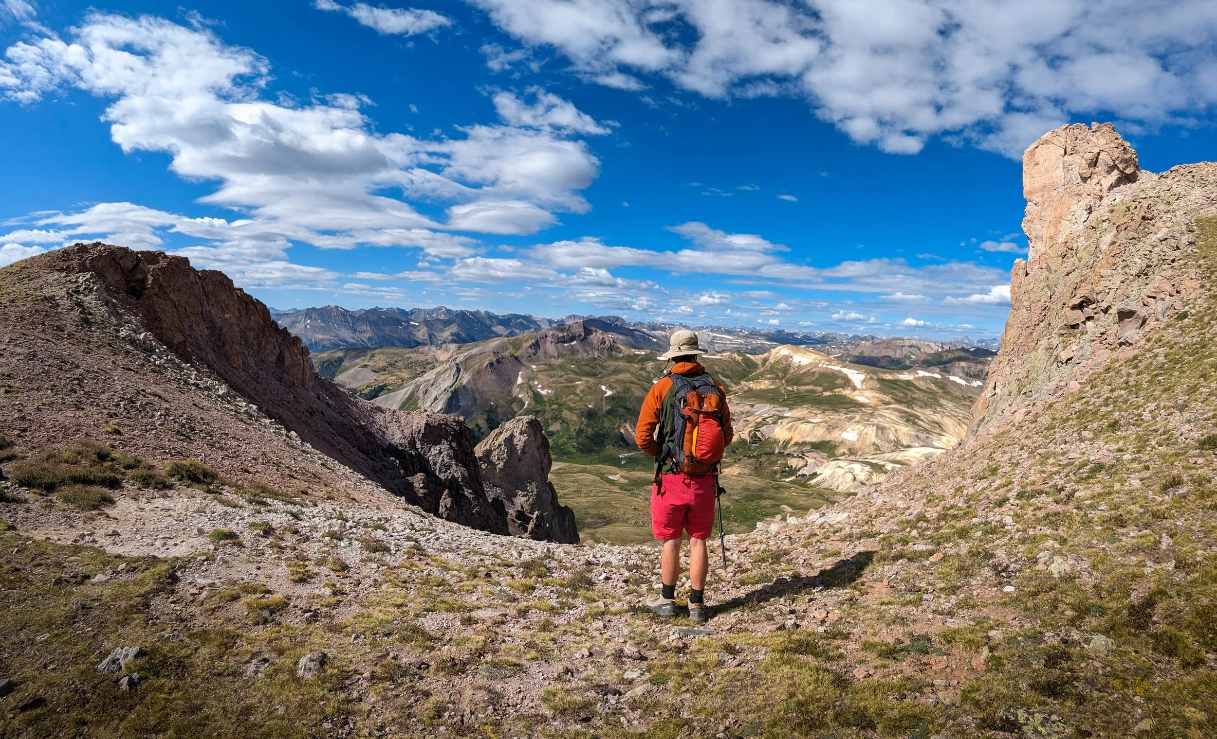
Carter parked the truck and we shouldered light packs. We set off in the cool morning air, and for the first mile or two, we felt pretty good. The climbing was steady as we broke above treeline and got our first glimpse of Wetterhorn and Matterhorn Peaks. My stomach churned. Carter was highly anticipating the Class 3 climbing we would find on Wetterhorn. I myself was dreading it. But first we would tackle Uncompahgre.
We turned past the towering peaks and followed a mostly flat trail around the corner to get our first view of Uncompahgre Peak. It rose prominently from the alpine tundra.
By this point, about 3 miles in, my legs were still feeling strong, but my gut hadn’t stopped its uncomfortable wrenching. Nearing sunrise, the temperature dipped, and I felt the sweat covering my body chill sharply. I started shivering as we hiked in a gentle breeze.
Sunlight began touching the surrounding peaks, teasing me with its warmth. Wetterhorn lit up with alpenglow. Despite my discomfort, I couldn’t help but soak it in.
We plodded along the trail, slowly approaching Uncompahgre. We were coming from the backside, so we’d have to hike around the mountain before going up it. The sun was rising on the far side of the mountain, so we hiked in the shade. I continued to shiver, chilled by the sweat soaked into my jacket. Typically, I’m able to quicken my pace to warm my body, but it didn’t seem to be working. I yearned for the touch of the sun as we marched on.
We climbed a loose hill into an open bowl. Ahead, we could see the trail traversing the bowl to gain a saddle. A rim of golden light backlit the grassy saddle; warmth was within reach. We began to traverse along the trail, and as we eyed the saddle, we noticed a pair of silhouettes come into view. Even from a distance, we could spot their majestic antlers, and we watched the elks on their morning stroll across the ridge. I was too entranced to pull out my camera.
Finally, we reached the saddle, where I met the sunlight with open arms. Between my stomach pain and my inability to control my temperature, I had had a rough morning. I sat in the warmth and swallowed some water and half a protein bar. Not feeling much better, I rose soon and continued on after Carter.
The summit block of the mountain loomed before us.
The trail climbed steadily and my legs slogged along. We climbed a couple long switchbacks up a huge talus field. Marmots and pika flitted in and out of the rocks, soaking up morning rays where they could. I took a break for my legs and my body. I had been struggling and I wasn’t sure why. Still, I knew I would make it to the top.
After the switchbacks, we gained a wide ridge up to the summit block. Down to our left, couloirs dropped almost 1,500 feet back to the valley floor.
The views up here were epic and the going was fairly easy. We made our way up the grassy slope, approaching the summit block. We donned our helmets and began some easy scrambling through a small boulder field. We traversed around, eventually finding a weakness in the summit block, a small but steep gully, with a mix of dirt and loose rock. We took turns making moves up the gully, using our hands to steady ourselves, careful not to push rocks onto each other.
Before we knew it, we were on the final slope to the summit. From here, it was an easy walk, but I was tired, cold, and in pain. We reached the highest point and plopped down on some rocks, admiring the well-earned view. Looking down the far side, the north face of Uncompahgre was utterly sheer. It was an epic spot.

The wind blew hard on the summit. I had already changed layers several times, and remained cold. Quickly, I retreated from the highest point and found a circle of rocks set up as a wind shelter. I crawled into the alpine foxhole and curled into a ball to warm up. Carter soon joined me in the hole and we fueled up for the descent. I was not particularly in the mood for climbing Wetterhorn on our way out, but we decided we’d make the final call when we got a bit closer. We got going.
We walked down the summit block, carefully downclimbed the gully, and marched down the grassy ridge to the switchbacks through the talus. Quickly, we were back down those too, and back to the spot we had seen the elks that morning.
We still had to descend the backside of Uncompahgre, before climbing back up into the basin that held Wetterhorn.

Miles nine through eleven felt like the longest section of the day. We crossed a few small streams and stopped at one point to fill our water bottles. Then the climbing began. It wasn’t steep at all, but our legs were feeling it. We moaned and muscled our way to the broad summit of a stout pass where we collapsed in exhaustion. Climbing Wetterhorn was out of the question at this point. We sat and soaked up the sun. It was the first time I had felt decent all day.
We snacked and chatted and enjoyed the view before gathering our things, shouldering our packs once more, and heading on down the trail.
Two more miles, and we were back at the car.

Back in Lake City, we fueled up and headed north, where we made another grocery stop in Gunnison. Our next destination would be Carter’s cabin outside of Telluride, so we grabbed supplies for living there, as well as some additional gear for camping. Our favorite piece of gear was a new Red Ryder bb gun.
After stocking up, we found a suitable dispersed campsite just outside of Black Canyon of the Gunnison National Park, and posted up for the night. We made dinner and spent the evening lounging in hammocks and shooting beer cans out of trees.
In the morning, we would embark on the next chapter of our journey. After one final grocery stop, we would head off the grid and out of service, to a small cabin nestled in the woods above a picturesque lake. The mountains were calling, so we hit the road.
PART 3 - TELLURIDE COMING SOON